Poistotuote
Tuotteen kuvat ja videot
Hintatiedot
Hinta 179,99 €.179,99
Maksa myöhemmin Tilillä
Saatavuustiedot
Lähetettävissä0 kpl
- Elinikäiset kameratolppapäivitykset
- 5" kosketunäyttö
- Reaaliaikaiset liikenne-ja säätiedot
- Reaaliaikaiset pysäköintitiedot
Maksupalvelut
Tuote-esittely
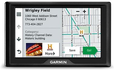
The Garmin Drive™ 52 is a fantastic 5-inch car navigator perfectly designed for vehicles, featuring a comprehensive map of Europe along with speed camera updates and driver safety alerts. With its clear menus and large buttons, this device is incredibly user-friendly. The voice guidance feels like having a friend by your side, utilizing street names and landmarks for easy navigation. You'll also enjoy TripAdvisor® hotel, restaurant, and attraction reviews, as well as Foursquare® points of interest, ensuring there's plenty to see and do along your journey. Lane guidance and junction views make navigating tricky intersections a breeze, while real-time traffic updates and parking information help reduce unnecessary stress. The UpAhead feature allows users to see upcoming points of interest, such as dining spots, gas stations, and attractions, all without leaving the map view.
Technical Specifications:
- Detailed maps of Europe. Check the specific map coverage here.
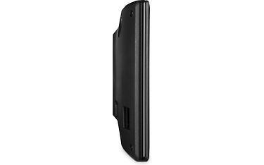
- Screen size: 5" (11.1 x 6.3 cm).
- Screen resolution: 480 x 272 pixels.
- Screen type: WQVGA TFT color display with white backlight.
- Battery: rechargeable lithium-ion.
- Battery life: up to 1 hour.
- Compatible with memory cards: microSD card (sold separately).
- Trip log: yes.
- Route planning: yes.
- Garmin Real Directions landmark guidance: yes.
- Foursquare points of interest: yes.
- Junction view (shows street signs at intersections): Yes (photoReal junction view).
- Dimensions: 14 x 8.4 x 2 cm.
- Weight: 170.8 g.
Preloaded Maps:
- United Kingdom: complete maps
- Scotland: complete maps
- Wales: complete maps
- Isle of Man: complete maps
- Northern Ireland: complete maps
- Ireland: complete maps
- Channel Islands: complete maps
- Gibraltar: complete maps
- Denmark: complete maps
- Finland: complete maps
- Iceland: complete maps
- Norway: complete maps
- Sweden: complete maps
- Andorra: complete maps
- Belgium: complete maps
- France: complete maps
- French Guiana: complete maps
- Guadeloupe: complete maps
- Martinique: complete maps
- Netherlands: complete maps
- Luxembourg: complete maps
- Réunion: complete maps
- Saint Barthélemy: complete maps
- Italy: complete maps
- Austria: complete maps
- Switzerland: complete maps
- Liechtenstein: complete maps
- Malta: complete maps
- Spain: complete maps
- Portugal: complete maps
- Gibraltar: complete maps
- Azores: complete maps
- Canary Islands: complete maps
- Balearic Islands: complete maps
- Madeira: complete maps
- Germany: complete maps
- Czech Republic: complete maps
- Greece: complete maps
- Cyprus: covers the entire Republic of Cyprus - includes major urban areas of disputed regions with roads connecting them
- Estonia: complete maps
- Latvia: complete maps
- Lithuania: complete maps
- Poland: complete maps
- Slovakia: complete maps
- Hungary: complete maps
- Slovenia: complete maps
- Croatia: complete maps
- Bulgaria: complete maps
- Romania: complete maps
- Turkey: complete maps
- Moldova: only major roads
- Bosnia and Herzegovina: complete maps
- Serbia and Kosovo: complete maps
- Montenegro: most urban areas
- Albania: complete maps
- Former Yugoslav Republic of Macedonia (FYROM): complete maps
- Belarus: only major roads
- Ukraine: most urban areas
Tuotekoodit ja brändi
- Tuotenumero
- 529673
- Brändi
- Garmin
- Valm. tuotekoodi
- 010-02036-11